
Blog 19: New South Wales, South Australia, Queensland & The Northern Territory - Tibooburra to A
- Apr 22, 2018
- 11 min read
One Thousand Nine Hundred and Twenty Seven Kilometres. Four States. Two Deserts. Seven Geocaches. It's been a big week!
On a crisp Monday morning, we tried to wind our body clocks back to 'rise before the flies to eat breakfast in peace' time. It took a few more days to get the rhythm right. Loading up on groceries at TJ's Roadhouse, and a full 120ish litres of diesel, we turned west and pointed Gary at the desert.
We wound our way on gravel, corrugations, the occasional sandy dune through the red scrubland that marks the transition into the Strzelecki Desert. The dry air of the Sturt National Park. The pleasantly mild high twenty-something air temperature and thousands and thousands and thousands of flies. At least they were the little annoying ones and not the big bitey ones.
We did a little hook turn through South Australia and found ourselves at Cameron Corner (Queensland). Adam was last here with his Nana and Grandad when he was nine years old. The corner plinth is the same. The red dirt is the same. The pub looks the same. Maybe the dog fence is in better condition. Two bucks a litre for diesel. What a spot. We decided to stay the night.


The pub is festooned with the caps of a thousand visitors, rank slides and unit patches, and signs everywhere 'Do not throw for the dog, no matter how soppy his eyes get. $20 donation to RFDS penalty.' The dog will bring a scrap of bark, or even a rock and plonk it expectantly at your feet. Hard to resist.
We wandered around the desert for a half an hour and got a three state multi-cache geocache (number 22), before returning to the pub to drink beers as the sun set. We ended up hanging out with a group of motorcyclists from Geelong who were on an off-road outback adventure on their dirt bikes. They began as eight, but were down to seven after one of their number hit a kangaroo the day before and needed to be air lifted to Adelaide Hospital. They were also bound for the Strzelecki Track the next day, continuing on in solidarity despite their injured companion.

We almost beat the flies the next dawn. The desert sky gets more beautiful every morning. It is a very different kind of light to the coast. Tuesday was a long day on the road. Crossing cattle stations, dodging cows, cresting dunes, dodging bulldust holes, gliding across corrugations, juddering across corrugations. Trying to find that perfect balance of tyre pressures that allows smooth travel over the corrugations while protecting sidewalls from sharp shredding rock. Gary likes 20/25 (psi front/rear) sometimes and 25/30 at others.
Across the Strzelecki Desert we drove. Then eventually we hit the Track. More of a wide, well maintained, very occasionally sealed road than a track nowadays. The development of oil and gas resources out near Innamincka means we passed a couple of sections with a water truck, grader, roller trio improving the road. Still vast, empty, arid, sparse and beautiful though. We stopped off by the Strzelecki Creek Crossing for Geocache 23 and continued out southwards run.


A desert is, by its very nature and definition, desolate. That makes stumbling upon the intensity of life that surrounds an oasis of life giving water all the more remarkable. In the middle of the desert is an artesian bore - Montecollina Bore. Sunk in 1903 (unconfirmed, couldn't find much info on it), the bore spills warm (46 degrees!) fresh water into a series of cooling ponds that have evolved into a wetland home to a variety of plant and bird species utterly absent from the rest of our desert crossing. There was even a solitary duck swimming in the first lagoon when we were there. Standing in the cool air downwind of the water, seeing the white ancient ocean-bed sand and scraggly dune shrubs, it is easy to feel like the beach must be just over the next sand ridge, instead of hundreds of kilometres away.


After lunch at Montecollina Bore (and finding geocache number 24), we continued along the Strzelecki Track to turn southwards at Mount Hopeless and follow the eastern flank of the Flinders Ranges. This drive along Mount Hopeless Road (apart from the 20 km north of Balcanoona which was really, really (Balladonia Road bad) corrugated) was one of the greatest drives we have done to date. Out of the sprawling desolate red earth and gentle hills of cattle stations, you see the northernmost end of the Flinders Ranges slowly rise above the horizon. The road turns away to the east, then back again, each time offering a different reveal of the sometimes rounded, sometimes jagged, striated red and yellow and purple and brown mountains rising into the sky. Desert gives way to increasingly wider creek lines. Sometimes there is a friendly cow. The Ranges grow and grow and consume the western horizon in stark contrast to the flat nothingness of the Lake Frome salt pan to the east. What a gorgeous drive.


We wound our way along the edge of the Vulkathunha-Gammon Ranges National Park to the Arkaroola Wilderness Sanctuary, a privately held conservation reserve in the northern section of the mountains (and another awesome place to visit recommendation by Grandma Davies). As dusk approached we got to see a couple of Yellow Footed Rock Wallabies (one made Gary test his stopping skills, and escaped with all his tail fur intact) around the place before pulling up, weary but safe after out desert crossing at Arkaroola village. Sunset amidst the ranges was a real treat - golden light on every hue of brown and red in the rock around us. We made our camp on dry rocky ground and slept a well earned sleep.

This part of the Flinders Ranges is still basically desert. Dry dry (dry) desert. Stony ground, empty creeklines and surprise at every animal bigger than an insect that has found a way to survive, or even thrive out here. Rising early to watch dawn creep its way slowly down the sides of the surrounding mountains was very special. We got shuttled to a trailhead and hiked about six difficult rocky, slippery and dry kilometres up and over a ridgeline back to the village. The view from the top was worth it. Not the highest peak around by any means, but high enough to give a full panorama of the surrounding rolling hills and slopes that make up these mountains. Trees cling to ridgelines. Dappled sunlight from the occasional cloud turned the undulating hillsides into blankets of red brown and drab green. To the east, beyond a few ridges, the flat salty expanse of Lake Frome. South, and far below, the winding gravel road we drove in on, and more peaks. North in the distance the desert we had crossed the day before. West the village nestled amongst the surrounding mountains. A dry and slippery hike down and a well earned cold beverage at the bar before an afternoon relaxing and hoping for the sky to clear.


That night we were treated to a stargazing observatory experience. Clear and crisp, the moon below the horizon, the stars were out in all their glory. Away from the light pollution of civilisation, we were treated to a grand view of the heavens. Greek alphabet constellation stars. Globular clusters and binary stars that seemed like single lights to the naked eye were revealed in their glory through the 2 400 x magnifying power of a telescope. We saw the Mexican Hat galaxy, fluorescing hydrogen gas clouds, stars of red (cool), yellow (warm) and blue (hot) and finished off with a view of Jupiter and her moons. The night sky out here is glorious, captivating and entrancing. Dreams that night were of distant worlds, alien life, and a little bit of Star Trek.

Rising early and finishing breakfast before the flies, we set out westwards for Leigh Creek to resupply. We drove a winding road through Italowie Gorge. Large white eucalypt trunks contrast with the red rock to create a sense of wonder that trees so big can grow out here. More cattle stations, the Aboriginal Community of Nepabunna and more cattle stations passed us by. This is the real outback. Communities holding onto culture amidst a land that has been ravaged by decades of pastoralism. The contrast between nature reserve and station is stark and heart sickening. The cattle industry continues to exploit the land to satisfy our societal craving for beef and leather. It isn't just the Amazon Rainforest (deforested for soybean monoculture to feed cattle) that suffers to feed the worlds hunger for beef. There are glimpses of what this great desolate artesian basin must have looked like before white people came along, but then there is more cow shit, more trampled and eroded landscape, scarred with cow trails, another beautiful sad cow or calf struggling to find the smallest patch of shade in the desert heat, so far removed from its natural ecosystem, another road train full of poor animals going to die. Australia is more than just National Parks and highways. There are some difficult truths about our (white people from the coastal cities) treatment of this land and the traditional custodians of this land that require exploring off the sealed road. I believe it is important to talk about these truths, think about how we feel about them and how our chosen actions and lifestyle challenge or reinforce the current way of doing things.
There is a lot of time for thinking on hundreds of kilometres of unsealed road.

We arrived at Leigh Creek for fuel, water and food. A strange almost-ghost town. This entire town was relocated here in 1982 from 13 kilometres away to get access to a large coal reserve it was on. Then the mine was restructured and eventually closed in 2015. There are houses, a hospital and a shopping precinct, all newer than 1982. And mostly empty. The tourism bureau, butcher, post office, craft store and newsagent have all condensed to within the walls of a single supermarket. Half the grocery shelves have been repurposed to stock other items like clothes, homewares and knick-knacks. There are empty shops everywhere. Everything looks the same age, the same architectural style, the same amount of wear and tear, which is really disconcerting when you think a normal town has evolved over years with newer and older structures and different trending styles in materials and appearance. Stocked up, we turned North towards Marree and the start of the Oodnadatta Track.
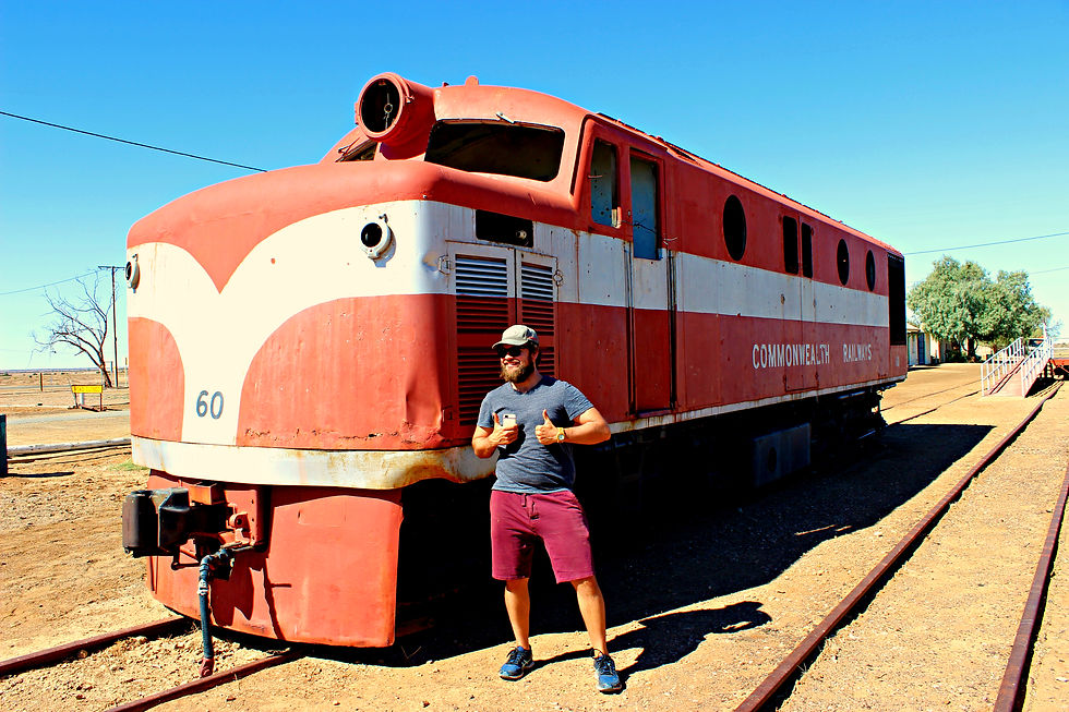
Marree has a great little exhibit on the old Ghan with an old engine, station and some other assorted railway bits and pieces. And geocache number 25. Also very awesome was the old mail truck that Tom Kruse used to drive the Birdsville Track in (a bit of an outback legend). After eating lunch we turned west again and were off on the iconic Oodnadatta Track, which roughly follows the route the Ghan train used to take.

Our first stop along the track in the early afternoon was a curious sculpture park in the middle of nowhere. Built around the original sculpture 'Planehenge,' a variety of constructions in steel dotted the open air gallery. Somewhat poetic was the two Pink and Grey Galahs nesting in the cockpit of one of the aircraft that make up the Planehenge sculpture. Natural aeronauts conquering their mechanical cousin. Also here was geocache 26.

Further along the track we touched the southern edge of Kati Thanda (Called Lake Eyre for the last couple of hundred years or so). This is the sixth largest lake in the world. And the lowest point in Australia at 13-15 m below sea level. Also our lowest geocache (number 27). The crisp white salt flat extends right across the horizon. It makes you feel very small. And it is hard to capture in a photo. Maybe one day we will get to visit when it is full of water and life. Although that is generally a once in a generation kind of thing.

Our stopping point for the night was a place called Coward Springs. An old railway siding with an artesian bore that has been turned into a magical little oasis. The bore is now a little artesian spa bath that was very relaxing to take a dip in after a long hot dusty day driving. We shared the spa with a man and his two sons, it was cozy but glorious. The place is mostly made from re-purposed old railway sleepers and other bits a pieces of the old railway siding. Very nice long drop toilets (beautifully painted interior with fish and swallow birds) with walls made from railway sleepers. And large Sheoaks fed by the bore giving blissful shade all around. Early morning bought a gentle spritz of rain. Not enough to even make the ground wet for any length of time, but an important reminder of before-bed camping rule #1: It could always rain. Even in the desert. So make sure things are under something.


A glorious desert sunrise, then it was on the road again. Our second day on the Oodnadatta Track saw us pass through William Creek, cross the largest cattle station in Australia (Anna Creek) explore a little off road around the ruins of Edwards Creek Siding before stopping at Algebuckina for geocache number 28 and a look at South Australias longest bridge. A steel construction 120 years old and still standing.


We stopped next at Oodnadatta itself. Fuel (but didn't hire canoes) at the iconic Pink Roadhouse. Only just over 200 km more of unsealed road to get to Marla, the bitumen of the Stuart Highway and our resting spot for the night. Somewhere in the nothingness of the Perdika Desert, about 70 odd kilometres out of Oodnadatta we came across a pair of cyclists heading in our direction. They assured us they had adequate water and were okay so we journeyed along this long, lonely, dusty, dry, desolate, occasionally cow inhabited landscape. I cannot fathom how someone could find riding a bicycle across here appealing, but I guess whatever floats your boat. We saw a little dingo near the end of the track.


We eventually made it to Marla. Oodnadatta Track complete, end to end. A cold beer was in order. For all the off road, gravelly, sometimes very corrugated adventured Gary had across the desolate outback, he is none the worse for wear (touch wood). A troubled and unsatisfying sleep at the campground by the truckstop was interrupted by road trains of cattle pulling up, an unsavoury fellow pawing around under our tent looking for things to steal from our camp at eleven pm (lock up your valuables, ALWAYS), cattle lowing to all hours and late night drivers rocketing past in the dark.
We woke before dawn and got the hell out of there early.


The quiet, smooth highway glides away beneath the wheels. The placement of tyres between every jagged looking, sidewall magnetic rock is no longer a concern. Cattle grids are gentle perturbations instead of ramps aimed skywards. There are no blind corners, creek dips, bulldust holes or corrugations. With a sleepless night, Adam is glad of the reduced intensity of driving. Gary misses the stuff he was designed for a little bit.
The Northern Territory. The final frontier. The one region of Australia neither of us have ever visited. We crossed that final border and saw our first ever 130 km/h speed limit sign. The highway seemed to lengthen and straighten. We kept doing a nice, safe, very fuel efficient 90 to 96 km/h. Adam very strongly resisted the nerdy impulse to turn right at Kulgera and drive out the 150 or so kilometres to visit Lamberts Centre of Australia near Finke. Maybe next time we are out this way.


We visited the Henbury Meteorite Craters, a short unsealed hop off the highway on our way past for an invigorating (and warm) walk around a crater rim. Finally, late afternoon, weary but safe we made it here to out camping spot, just outside Alice Springs. There are shady gums, monumental rock faces and friendly people. The Macdonnell Ranges seem expansive, impressive and alluring. We will be off to explore them and the town on Monday. But for now. Rest. Recuperation. A bit of washing and some relaxation.
All our love,
Adam and Ruth
foragingforvegantreats
Statistics Update:
Days on the Road = 132
Distance Driven = 16 295 km
Mean Distance per Day = 123 km
Mean Fuel Economy = 13.73 L / 100 km
Best Fuel Economy = 12.17 L / 100 km (Port Lincoln to Port Augusta)
Nights Free Camping = 31
Nights in Roof Tent = 117/131
Coffees Purchased = 46
Instagram Posts = 334
Instagram Followers = 165
Geocaches Logged = 28
Gary Breakdowns = 0.1
Drone Flights = 2
Videos Made = 0
French Land Rover Drivers Scared = 1
State or Territory Borders Crossed = 13
Bucks Parties Accidentally Crashed = 1
Vegan Vanilla Slices Eaten = (Adam 2, Ruth 1)
Times Set Up Camp after Dusk = 2
Chairlifts Not Used = 1
Waves Returned by Tasmanian Land Rover Drivers = 2
Cups of Tea Made for Strangers = 1
Tasmanian Short Walks Completed = 10/60
Rounds of Lost Cities Played = 68
Longest Continuous Sleep in Roof Tent = 11 hours
Gary Oil Changes = 1
Blood Donation Dates = 1
Sick Days = 4 (Adam 4, Ruth 0)
Australian Deserts Visited = (2/10) (Strzelecki, Perdika)
Cattle Stations Camped On = 1
Iconic South Australian Track Completion = Oodnadatta 100% (617 km), Strzelecki 26% (122/475 km), Birdsville 0% (0/517 km)


Comments